WAMSI-MP (Waqf Asset Management System of India – Madhya Pradesh) is a comprehensive digital governance initiative undertaken to modernize, secure, and institutionalize the management of WAQF properties across the state of Madhya Pradesh. The project was conceptualized to address long-standing challenges related to fragmented records, lack of spatial clarity, encroachments, legal disputes, and limited transparency in WAQF asset administration. By leveraging GIS technology, digitization of records, and centralized data management, WAMSI-MP establishes a single, authoritative system for managing WAQF assets in the state.
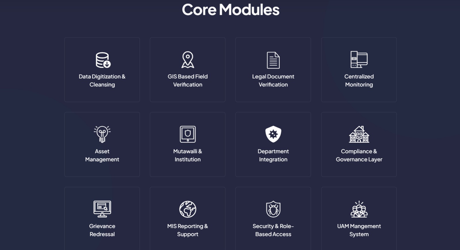
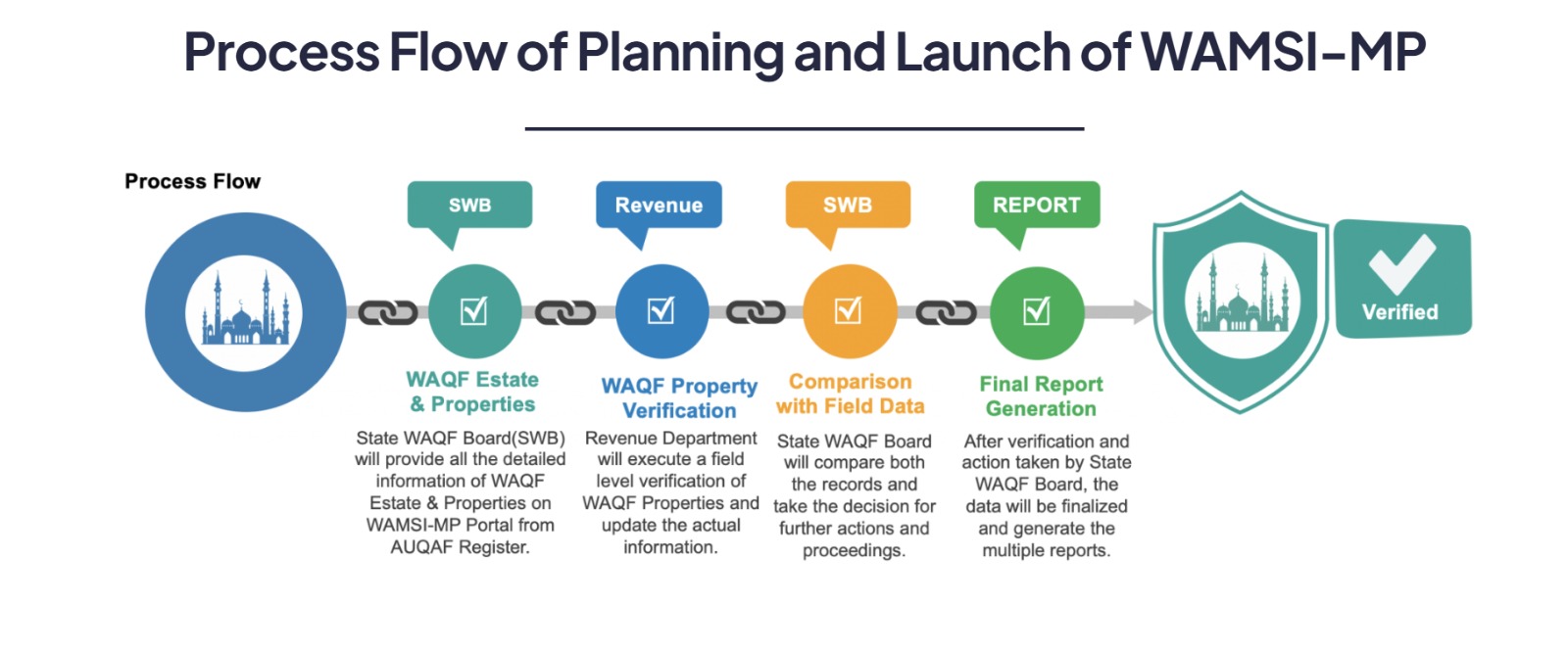
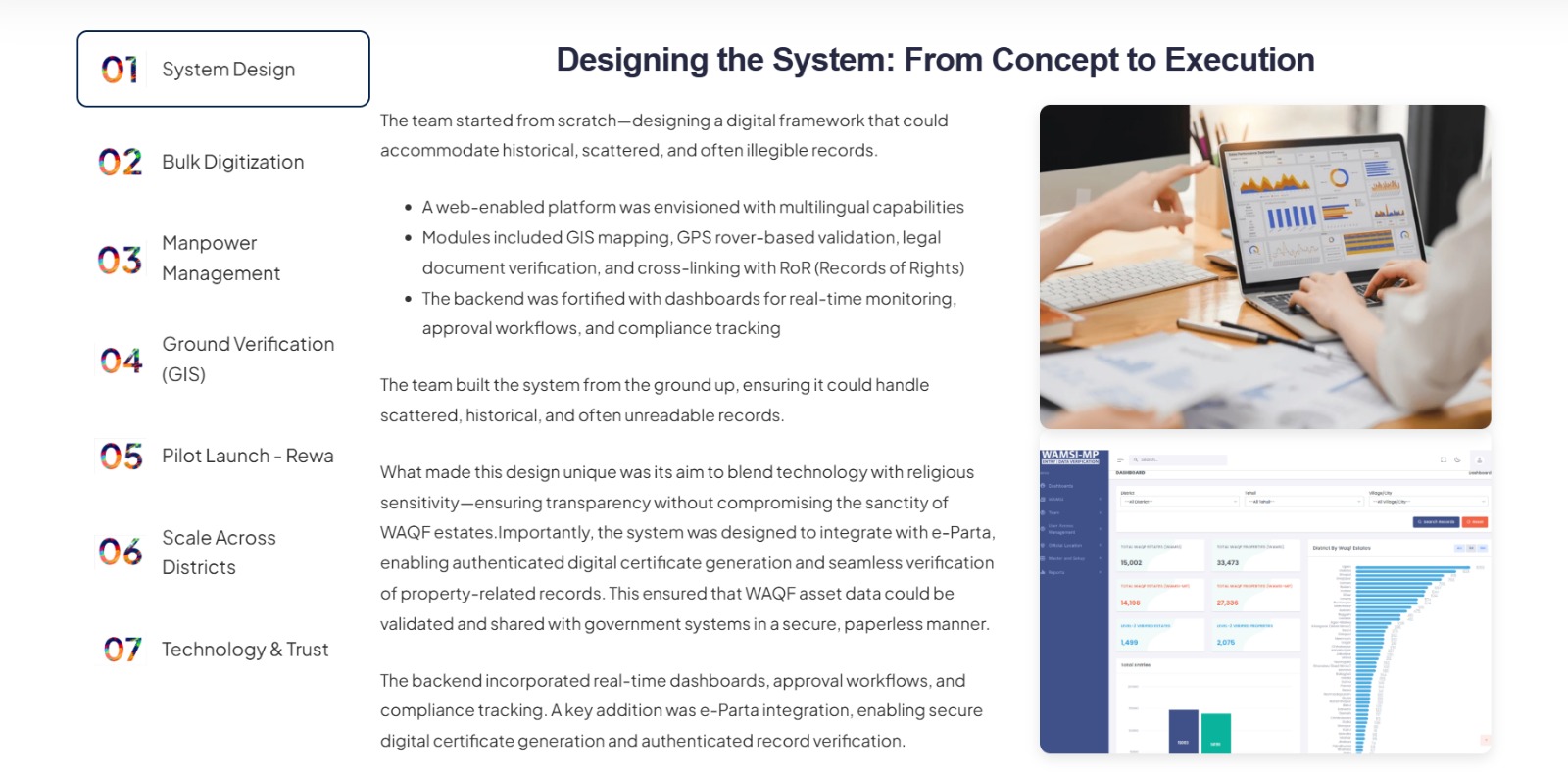
Under WAMSI-MP, WAQF properties were digitally mapped and geo-referenced using GIS, linking spatial boundaries with textual and legal records. This integration created a single source of truth, enabling administrators to view property details, boundaries, location, and ownership information on a unified digital platform. The project replaced legacy paper-based registers and disconnected datasets with a structured, searchable, and secure digital repository, significantly improving data accuracy and accessibility.
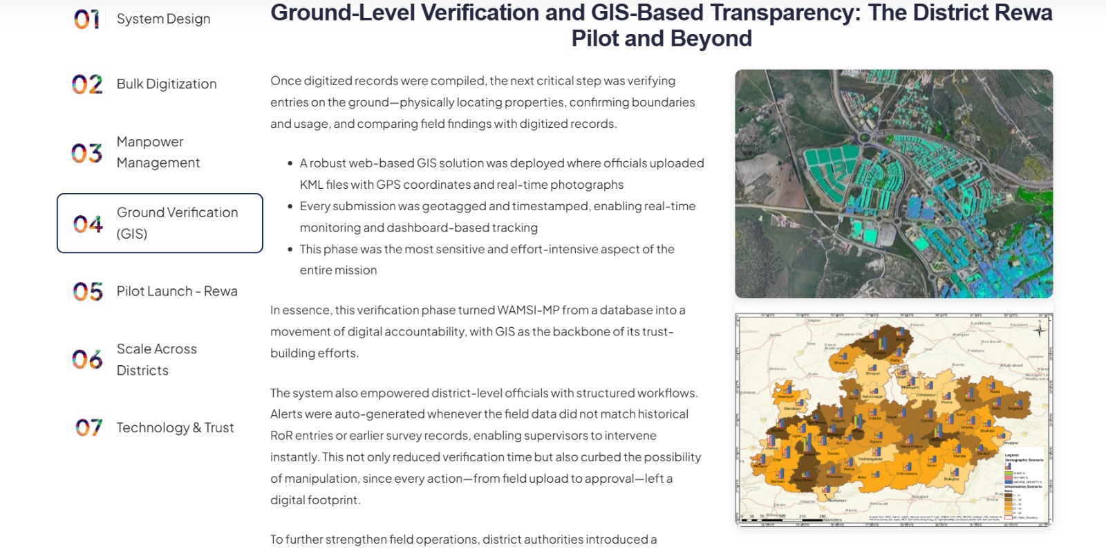
A key objective of WAMSI-MP was to protect WAQF properties from encroachment, misuse, and unauthorized transfers. Accurate boundary mapping and spatial verification allow authorities to identify vulnerable properties, detect overlaps or encroachments, and take timely corrective action. The availability of GIS-based evidence has also strengthened the WAQF Board’s ability to handle disputes and legal proceedings more effectively, reducing ambiguity and dependency on manual documentation.
Beyond asset protection, WAMSI-MP enhances transparency and governance by enabling better monitoring, reporting, and decision-making. Administrators gain access to dashboards and spatial analytics that support planning, prioritization, and compliance monitoring. The platform facilitates improved audit readiness and statutory compliance by maintaining consistent, up-to-date records that can be easily verified and reported.
WAMSI-MP has been designed as a scalable and replicable digital governance model, capable of supporting future enhancements such as integration with land records, urban local body systems, and public information portals. By institutionalizing technology-driven asset governance, the project not only strengthens WAQF administration in Madhya Pradesh but also sets a benchmark for transparent and accountable management of religious and charitable assets across the country.
WAMSI-MP has significantly improved transparency in the management of WAQF properties by replacing fragmented, paper-based records with a centralized, GIS-enabled digital system. Administrators can now access accurate, location-verified property information through a single platform, reducing ambiguity and inconsistency in records. This enhanced transparency has strengthened institutional credibility and increased trust among stakeholders, including beneficiaries, regulators, and the public.
The availability of structured and verifiable data has also improved internal governance, enabling officials to respond more effectively to information requests, audits, and oversight requirements. As a result, WAQF administration has shifted toward a more open, accountable, and data-driven model.
One of the most critical impacts of WAMSI-MP has been its role in protecting WAQF properties from encroachment, misuse, and unauthorized occupation. Accurate GIS-based boundary mapping and geo-referencing have provided clear spatial evidence of property extents, enabling early identification of encroachments and boundary overlaps. This has strengthened the ability of authorities to initiate timely preventive and corrective actions.
In legal and administrative proceedings, digitally mapped records have improved the quality of documentation and evidence, reducing disputes and accelerating resolution. The system has thereby contributed to safeguarding valuable WAQF assets and preserving them for their intended religious and charitable purposes.
WAMSI-MP has strengthened governance by institutionalizing standardized digital records and workflows across the WAQF asset management ecosystem. The platform supports consistent record maintenance, easier verification, and improved compliance with statutory and regulatory requirements. This has reduced dependency on manual registers and minimized risks associated with data loss, manipulation, or inconsistencies.
From an audit perspective, the centralized digital repository ensures audit readiness by providing verifiable, up-to-date records that can be easily reviewed and reported. This has improved administrative efficiency and reduced the time and effort required for audits and inspections.
The integration of GIS analytics and dashboards has enabled data-driven planning and decision-making for WAQF authorities. Administrators can analyze spatial distribution of properties, identify underutilized assets, prioritize protection measures, and plan development or maintenance activities more effectively.
This analytical capability has transformed WAQF asset management from a reactive process to a proactive governance function. By enabling informed decisions and strategic planning, WAMSI-MP supports sustainable utilization and long-term preservation of WAQF assets.
Beyond immediate outcomes, WAMSI-MP has established a scalable and replicable model for technology-enabled asset governance. The project demonstrates how GIS, digitization, and centralized data management can be effectively applied to manage large, complex property portfolios with high governance sensitivity.
The success of WAMSI-MP positions it as a benchmark for other states and institutions seeking to modernize asset management systems. It highlights the potential of digital governance solutions to enhance transparency, accountability, and protection of public and community assets at scale.
WAMSI-MP enables accurate GIS mapping and geo-referencing of WAQF properties across Madhya Pradesh. Each property is spatially identified with precise location coordinates and boundary delineation, providing a visual and authoritative representation of WAQF assets on digital maps.
The system maintains a centralized digital repository of all WAQF properties, integrating spatial data with textual, legal, and administrative records. This creates a single source of truth and eliminates dependency on scattered paper registers and legacy records.
WAMSI-MP links GIS maps with key property details such as ownership information, survey numbers, usage type, and legal status. This integration enables administrators to access complete property information through a unified digital interface.
Through boundary mapping and spatial analysis, the platform supports identification of encroachments, overlaps, and vulnerable properties. Authorities can monitor high-risk assets and take preventive or corrective action based on verified GIS evidence.
The system provides advanced search and filtering capabilities, allowing users to locate properties based on district, location, type, or legal status. Interactive maps and visual layers enhance ease of access and understanding of asset distribution.
WAMSI-MP offers dashboards and reporting tools that support administrative oversight, planning, and compliance monitoring. GIS analytics help identify trends, prioritize protection measures, and support strategic decision-making.
Digitized records and standardized data structures improve audit readiness by ensuring that property information is accurate, verifiable, and easily retrievable. This strengthens compliance with statutory and regulatory requirements.
The platform is designed to support future expansion, including integration with land records, urban local body systems, and other governance platforms. Its modular design makes it replicable for WAQF Boards and asset governance initiatives in other states.
Single Source of Truth for WAQF Assets
WAMSI-MP consolidates spatial and textual records into a centralized digital system, eliminating duplication and inconsistencies across legacy registers and departments.
Enhanced Transparency and Accountability
Digitized and geo-referenced property records improve visibility and trust, enabling stakeholders to access accurate and verifiable WAQF asset information.
Effective Protection Against Encroachment
GIS-based boundary mapping helps identify encroachments and overlaps early, strengthening preventive action and safeguarding WAQF properties.
Improved Governance and Compliance
Standardized digital records support statutory compliance, audit readiness, and systematic oversight of WAQF assets.
Faster Dispute Resolution
Accurate spatial data and linked legal records provide strong evidence for resolving land and ownership disputes efficiently.
Data-Driven Planning and Decision-Making
GIS analytics and dashboards enable informed decisions on asset utilization, monitoring, and long-term preservation strategies.
Reduced Administrative Burden
Automation and centralized data reduce manual record-keeping and repetitive verification, improving operational efficiency.
Scalable and Replicable Model
WAMSI-MP offers a future-ready, replicable framework for digital asset governance that can be extended to other states and institutions.